The Surface Water Department is one of the core sections in Water Resources Authority that is responsible for monitoring of the surface water component of the Hydrologic Cycle. The department collects, stores and analyses hydrological and meteorological data to facilitate equitable water resource allocation, design of water resource infrastructures, early warning on floods and droughts, water resources decision support etc.The following are the functions of the department:
- Surface water assessment and monitoring
- Identification and mapping of surface water resources
- Designing and Developing hydro-meteorological monitoring network
- Developing guidelines, standards, and procedures for surface water monitoring
- Construction, installation and maintenance of the surface water monitoring network
- Coordination of hydro-meteorological data collection; including engaging stakeholders and gauge readers for data collection
Analysis and interpretation of surface water data and information Surface Water Capital Projects One of the capital projects funded by GoK is Construction and Rehabilitation of Water Resource Monitoring Stations. Water Resources Authority is strengthening the hydro meteorological monitoring system by automating the stations to collect and transmit real/near real time data. The authority has also rationalized an optimum 223 surface water monitoring stations and 260 climatic stations. During the Financial Year 2020/2021, Water Resources Authority (WRA) committed to maintain operation of 40 Telemetric stations by loading airtime for transmission of data, battery maintenance and replacement cleaning of sensors.
The following 27 Stations were maintained by loading airtime at the end of Quarter 2: 1AA01 Malaba River and 1AH01 Sio River in Lake Victoria North basin area; 1GD02 Nyando River, 1HB04 Lake Victoria, 1JA(new) Ndoinet River, 1JG04 Kipsonoi River, 1JG04 Sondu River, 1KB05 Kuja Migori River, 1LA03 Kipsonoi River in Lake Victoria South basin area; 2B33 Suam River, 2B21 Turkwel River, 2EE07B Perkerra, 2EG03 Molo River, 2FC19 Njoro River, 2GD06 Lake Naivasha, 2K04 Ewaso Narok in Rift Valley basin area; 3DA02 Athi River at Munyu, 3F09 Athi River at Kibwezi, 3BA10 Ruaka River in Athi basin area; 4CA19 Karimenu River, 4BB08 Ragati River, 4CC08 Thika River, 4DA11 Thiba River, 4DD02 Thiba River, 4G01 Tana at Garissa in Tana basin area; 5BE01 Nanyuki River, 5ED01 Ewaso Ng’iro River in Ewaso Ng’iro North basin area.
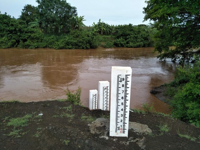
The Authority is also set to automate additional 5 regular gauging stations during the Financial Year 2020/2021. The Terms of Reference (ToR) for construction, Supply, Installation, Training, Branding and Commissioning of 5 Multi-Parameter Water Level Telemetry Stations has been prepared, tender documents approved awaiting advertisement in Water Resources Authority and Public Procurement and Information Portals. Manual Data Collection to Telemetry Over the years, private gauge readers have been engaged to take manual readings at River and weather stations on behalf of the entities in charge of the stations (i.e Ministry of Water, Water Resources Authority and Kenya Meteorological Services). Water levels (Rivers and lakes) are normally collected twice daily while climate data (rainfall, evaporation, temperature etc.) is collected once daily. Automatic chart recorders installed in key stations have been phased out and logging stations introduced in the late 1990s. Logging stations complemented manual gauges, increased the frequency of data capture ( 30 minutes, hourly, 2 hourly etc.) and enhanced data plausibility.
Manual Staff Gauges Logging Rain gauges To ensure quality data and timely transmission, Water resources Authority embarked on a program to automate and upgrade its monitoring stations to transmit real time data to a central server. This is coupled with installation of a Water Resources Information Management System (WRIMS) that enables Data management, Flood forecasting and Drought forecasting. The system enables data capture, data processing and information packaging. The information is used in apportioning and allocating water resources as well as for regulation and enforcement purposes. The main purpose is to generate accurate and reliable data and information on water resources in a timely manner to enable planning and decision making on investment with the following main features:
- Surface water monitoring network establishment which includes installation of telemetric stations that gather and transmit water resources data and information on real time basis.
- Data analysis and packaging for utilization in decision making and planning.
- Water Resource Information Management System.
The key outputs/Products are:
- Country/County/Basin water resources assessment and databases indicating water resource availability in terms of quantity and quality
- Models for Water resources forecasting and to guide investments
- Models for Flood early warning
- Hydrological reports and bulletins (year books, quarterly and monthly water situation reports)to inform all water users on the water situation in country.
- Criteria for water allocation and apportionment
- Scenarios for water resources planning, balancing, transfers and development
- Data and Information for Management of Floods and Droughts Currently, WRA has upgraded 118 surface water monitoring stations to real time data transmission out of which 63 are river monitoring stations and 55 climatic monitoring stations.